There is no longer any doubt about the projected impact of the space transportation industry on our lives. Over the course of the last decade, the United States — and many other countries — have experienced rapid growth of commercial space activities in areas of space tourism, earth observation, global communications, medical research, science, and engineering.
The establishment of licensed spaceports was not a topic that garnered much consideration ten years ago, but today there are 21 active spaceports in the U.S. that can be used for commercial space activities, licensed by the Federal Aviation Administration (FAA). A number of federal launch and reentry ranges, state/locally owned spaceports, and privately-owned spaceports are conducting regular and more frequent space launch activities at an ever-increasing rate (see chart at center right).
Shown here is a map of all active U.S. Spaceports for FAA-licensed operations. FAA image.
Perhaps the best-known spaceport is NASA’s federal public facility known as the Kennedy Space Center in Florida. Just a few weeks ago, Elon Musk’s SpaceX company flawlessly launched a Falcon 9 rocket from there, with four diverse astronauts — including a Russian cosmonaut — to the International Space Station (ISS). It was the fifth operational human spaceflight mission to the ISS conducted by a commercial company since NASA retired its Space Shuttle Program in 2011. Two days later, SpaceX launched yet another rocket with two Intelsat satellites from another well-known federal spaceport — Cape Canaveral Space Force Station in Florida.
FAA-licensed launches since 1989. FAA chart.
And then there is actor William Shatner — “Captain Kirk” from Star Trek — who became the oldest person to go in space aboard Blue Origin’s hot-water-heater-shaped NS-18 spacecraft last year. That joy ride began and ended at Launch Site One in West Texas, one of two private spaceports in the U.S. And we haven’t even talked about Virgin Galactic’s suborbital SpaceShipTwo vehicle, which takes off by using traditional aircraft from the long runways at Spaceport America in New Mexico.
On Oct. 5, 2022, a SpaceX Falcon 9 rocket carrying the company’s Crew Dragon spacecraft was launched on NASA’s SpaceX Crew-5 mission from the Kennedy Space Center in Florida to the International Space Station (ISS). This is the fifth crew rotation mission of the SpaceX Crew Dragon spacecraft and Falcon 9 rocket to the ISS as part of the agency’s Commercial Crew Program. NASA/Joel Kowsky image.
While companies like Virgin Galactic and SpaceX get the attention, it is the network of spaceports that serves as a critical pillar of the industry. While these facilities see little profit from launching $50 million satellites, spaceports serve as powerful drivers for local economies, providing value in the same way a major airport does today.
Blue Origin’s NS-18 spacecraft takes off from Launch Site One in West Texas, carrying William Shatner of “Star Trek” fame. Blue Origin image.
What is a Spaceport, Anyway ?
In general terms, a spaceport is a site for launching or receiving spacecraft, like a seaport for ships or an airport for aircraft. There is no generally accepted definition for the term “spaceport.” Spaceports are not all the same, with many having very different kinds of operations. For example, a spaceport can serve solely as a rocket launch site that contains one or more launch pads. Known as a “vertical” spaceport, these facilities are typically surrounded by a large safety area – called a “range” — over which launched rockets are expected to fly, and within which some components of the rockets may land. A spaceport may also include runways for takeoff and landing of aircraft to support spaceport operations — like Spaceport America — to enable support of winged launch vehicles. These facilities are known as “horizontal” spaceports. Some spaceports have both vertical and horizontal capabilities.
Virgin Galactic flies from Spaceport America in New Mexico. Virgin Galactic image.
As the capability of the commercial space industry expands, regulators like the FAA face new challenges to maintain public safety while enabling industry growth. Launch and launch site authority was originally granted to the FAA in 1984 for U.S. operators and spaceports. And while the FAA does not yet certify the design of commercial launch or reentry vehicles, the agency licenses the operation of the launch or reentry vehicles for public safety. Since 1989, the FAA has licensed nearly 500 commercial space launches and more than 30 commercial space reentries.
The FAA also licenses the operation of spaceports that are non-federal launch sites.
Launch Site Licensing
An applicant for an FAA-issued spaceport license must meet all safety, environmental, policy and risk requirements. This site license does not authorize any single launch; for launches to occur, a commercial space company must obtain an FAA launch operator license by meeting other regulatory requirements.
The SaxaVord Spaceport vertical launch site taking shape on the Shetland Islands in Northern Scotland. SaxaVord Spaceport image.
The FAA does not review the business case for a proposed spaceport, nor the justification for the specific location. However, there are plenty of hoops to jump through to obtain a license for a spaceport, with safety being at the top of the list. Here are four major areas described in FAA rules for a spaceport “applicant” to consider:
• Environmental impact – the applicant must prepare an “Environmental Assessment” or “Impact Statement.” These types of assessments can be very costly and time-consuming.
• Location – the proposed location of the spaceport must ensure that the chance of a single human casualty during a launch does not exceed one in 10,000. More on this later.
• Explosions – The applicant must submit a site plan that identifies where all explosive materials will be placed, while ensuring that their placement is separated from public areas and traffic routes in accordance with a sliding scale of explosive material weight and type versus separation distances.
• Launch Debris Path – The applicant must depict plans to ensure that damage and/or injuries from any debris shed from a malfunction or catastrophic failure is minimized.
Scott Hammond, Deputy CEO of SaxaVord Spaceport. SaxaVord Spaceport image.
Successfully navigating these areas of the licensing process can be very time-consuming, taking several years.
Pam Underwood; Director, FAA Office of Spaceports. FAA image.
FAA Office of Spaceports
Recognizing that spaceports play a critical role in the commercial space industry, Congress established the Office of Spaceports in the FAA Authorization Act of 2018. The Act stated: “A robust network of space transportation infrastructure, including spaceports, is vital to the growth of the domestic space industry and America’s competitiveness and access to space.” The FAA Office of Spaceports is responsible for development of policies that promote infrastructure improvements, strengthen the competitiveness of U.S. spaceports, support launch and reentry site licensing activities, and provide technical assistance and guidance to existing and proposed new spaceports.
“None of this is any small feat,” said Pam Underwood, the director of the office, during a meeting of the Global Spaceport Alliance. “These are detailed activities that we take very seriously.” Underwood’s office also chairs the newly created National Spaceport Interagency Working Group (NSIWG) — a dedicated team of experts from multiple federal government and state agencies, industry, and academia — to leverage the full network of spaceports to the benefit of the space transportation industry.The office is also working to modernize the regulation of launch and reentry sites, and coordinate those regulations with those under development in other nations.
An International Affair
Coordination of international commercial space regulations is a time-consuming task for Underwood’s office. That’s because a total of 64 licensed — or soon-to-be licensed — spaceports currently exist across 20 nations on our planet, with many more expressing interest in establishing such a facility. The U.S. leads the world with 14 licensed spaceports, followed by the United Kingdom (U.K.) with seven, Russia with five, and China and Australia each with four. Spain, India, North Korea, Japan, and New Zealand each have two spaceports. Ten other countries — such as Norway, Brazil, and Canada — each have one spaceport.
Despite where a U.S. operator initiates a commercial space launch or reentry — such as from a spaceport in Scotland, for example — a license from the FAA for the operation is required. This is in addition to host country’s regulations and licensing for the operation and the spaceport. Typically, a nation’s civil aviation authority is in charge of the licensing. For example, in the United Kingdom, the U.K Civil Aviation Authority (CAA) has a similar process of licensing commercial space launches and spaceports as the FAA process.
One such spaceport in the SaxaVord Spaceport, located in northern Scotland on the Shetland Islands in the village of Unst. The private spaceport was conceived five years ago when a report commissioned by the U.K. Space Agency had singled out SaxaVord as the preferred site for satellite launches. SaxaVord began with a staff of five people in 2017, growing to nearly 50 today. Construction of the spaceport began earlier this year and is expected to be completed by the Spring of 2023.
Scott Hammond is the deputy chief executive officer of SaxaVord, and he spoke with Aerospace Tech Review about his spaceport. A former RAF fighter pilot, Hammond is passionate — and patient — when it comes to establishing a successful location for commercial space operators to show their stuff. Two of three planned launch pads are being built now, with a third to be built in 12 months.
“The challenges are all around the CAA regulations,” explained Hammond. He ticked off a punch list of activities: airspace change process…looking at international agreements for splashdown zones…obtaining a marine license…showing that the location is safe.
“Coordination is key,” he said. “It’s all about baby steps.”
Hammond also articulated that four licenses will be required – for the spaceport, the range/airspace, launch vehicle, and satellite — before SaxaVord succeeds in performing what may be the first-ever vertical launch to orbit from British soil. SaxaVord is set to host the U.K .Space Agency’s “Pathfinder” launch, which will be delivered by two U.S. companies in 2023. A rocket manufactured by ABL Space Systems in El Segundo, California, will launch and release a small orbital maneuvering vehicle built by Lockheed Martin which can carry and deploy up to six “6U CubeSats” — satellites that are about the size of a portable microwave oven — optimizing orbital placement for each satellite’s respective mission, whether it be for earth observation, communications, or scientific research.
A Virgin Galactic SpaceShipTwo spaceplane at Spaceport America in New Mexico. Virgin Galactic image.
Location, Location, Location
The geographic positioning of a spaceport is a key consideration for both safety and commercial viability. A spaceport must be built as far as possible away from major population centers in order to mitigate risk to bystanders should a rocket experience a catastrophic failure. Many spaceports with launch sites are built close to large bodies of water to ensure that no components are shed over populated areas. A spaceport site should also be large enough to prevent death, injury, or damage to adjacent launch pads in the event a vehicle explodes.
Some spaceports use adjacent restricted, remote airspace as a competitive advantage, such as Spaceport America in New Mexico, which is located on large swaths of land below the Department of Defense’s restricted airspace at White Sands missile range.
“You can’t put a launch site anywhere” Hammond explained. “Things do go wrong sometimes. You don’t want to overfly any populated areas in case there is a problem.” Because Saxavord is located in the most northern section of the UK it provides these safety features, and also commercial advantages. Spaceports located at high latitudes can provide direct to low-earth orbit trajectories, which means less fuel needed to get to orbit, equating to more payload capability.
“Our site here in the Shetlands is ideal for satellite launches,” Hammond stated. He explained that the spaceport is well-positioned to launch small satellites into Polar and Sun-Synchronous orbits. It provides a safe trajectory for rockets to carry satellites to these orbits, and has no population centers over the launch path. He also explained that the airspace around the spaceport is clear, with no commercial airline or military activity to get in the way of a launch or reentry vehicle. As an added bonus, the site has significant logistical infrastructure and supply chain expertise that was previously built to support the oil and gas industry there.
The Commercial Space Field of Dreams
SaxaVord is one of seven “aspiring” spaceports in the U.K., and it is the only private one. The spaceport no longer needs to advertise its facility like it once did five years ago; it currently has applications for 30 launches. “Seven clients are looking to launch by 2024,” Hammond explained.
There are many more “applicants” for spaceports in the U.S.
The famous quote from the baseball film “Field of Dreams” sums up the mantra of the commercial space industry when it comes to spaceports: “If You Build It, They Will Come.”
From the early days of aviation over a century ago, advances in aerospace technology have depended mostly on tests conducted under actual flight conditions. The wireless transmission and reception of flight test data — known as telemetry — first became widespread in the 1950s and has allowed near-real-time access to engineering data required to reduce risks and costs while incrementally advancing technology.
Telemetry is critical for the aviation industry to deliver new products. It’s a key asset to aerospace research, testing and FAA certification. Higher speeds, altitudes and performance requirements, combined with increasingly complex and integrated systems, have added to the need for instantaneous test data.
Airplanes, helicopters, missiles, commercial space vehicles, unmanned aircraft systems, and electronic vertical takeoff and landing aircraft are all born as “test articles” and must be pushed to their limits in flight tests to succeed. For example, “flutter” tests are performed to stress the wings and control surfaces to the point where aerodynamic, elastic and inertia forces can produce potentially violent oscillations that, once begun, are difficult to control. Likewise, flight envelope-expansion testing, such as stall, spin, and dive tests, requires that aircraft be flown to the limits of their airspeed and load factor design capabilities. All of these tests are inherently dangerous to the pilot and persons on the ground. Even routine tests can involve significant safety risks.
Telemetry allows controllers on the ground to monitor the second-by-second performance of a test article. Controllers can warn a TA pilot to abort maneuvers that threaten a structural failure, out-of-control flight, or other system emergency. And real-time data captured can be analyzed to resolve potential problems that could make or break a new aerospace design, or even aid in reconstructing the cause of a crash.
Drinking from a Data Firehose
An aerospace industry survey conducted in 2014 indicated a fourfold increase in the number of flight tests conducted over a three-year period (2009-2011). Moreover, the number of test measurements is growing exponentially with the increased requirements to fly at higher altitudes and faster speeds. According to a 2004 study conducted by the MITRE Corporation, the amount of data required to be telemetered from aircraft test points had roughly doubled every three to five years since 1972, with few signs that this rise has abated. For example, the FAA certification process for the Boeing 707 airliner in 1954 included the electronic monitoring of 300 data channels. By 1995, certification for the Boeing 777 aircraft included the monitoring of approximately 64,000 channels. In 2011, the flight testing required to certify the Boeing 787 exceeded 200,000 individual data channels.
TmNS represents a paradigm shift from Pulse Code Modulation (PCM) to Ethernet-based telemetry. As shown in the graphic above, TmNS allows “bidirectional” communications for real-time access to current and past measurements of the aircraft in order to “back fill” any data drops during testing. Curtiss-Wright image.
The frequency and precision of measurements have also increased, with current tests requiring over 400 test samples per second that output up to 32 bits per sample. Test aircraft now routinely collect data at a rate of several gigabits per second. However, due to bandwidth limitations, the rate at which that data can be transmitted is only about 5 to 15 megabits per second, forcing test engineers to transmit only the most critical aircraft safety data being collected.
Graphic 2 — Curtiss-Wright recently developed the nXCVR-3140A-2, which is an Internet Protocol (IP) transceiver designed for air-to-ground and ground-to-air wireless TmNS-based communications. The air and ground transceivers work together to perform wireless router functions transparently, connecting two or more radios in a point-to-point or multipoint configuration. Curtiss-Wright image.
Not Your Father’s Telemetry
Because flight test instrumentation has changed so dramatically over the last decade, data acquisition units have transitioned from using protocols like Pulse Code Modulation (PCM) — which are limited by frequency bandwidth availability — to Ethernet. In order for these cutting-edge protocols to be uniformly applied to the industry, standards must be developed. The standards body for flight testing is the Inter-Range Instrumentation Group, and the standard specifically developed for telemetry is published under IRIG 106.
The 19th revision of IRIG 106 (IRIG 106-19) introduces the application of a new tool for flight test telemetry industry known as the Telemetry Network Standard. The system requirements for TmNS touch all the standard flight test equipment, including data acquisition units, switches, recorders, radios, and the ground elements such as the antenna and the ground system software.
TmNS aims to move telemetry into the network age, representing a paradigm shift from unidirectional PCM architectures to something akin to existing Internet-based networks. A fundamental principle of the TmNS approach is to enhance, rather than replace, today’s telemetry systems by providing significant improvements in frequency spectrum efficiency in order to more effectively handle vast quantities of data.
“Ranges in the U.S. are now rolling out TmNS-aware equipment for current flight test programs,” said Paul Cook, director of missile systems for Curtiss-Wright Defense Solutions, with 40 years of experience at the company. “Telemetry has been around since the 1950s. What’s changed is the amount of data. It’s a fun time right now in telemetry.”
Sridhar Kanamaluru agrees. He also works at Curtiss-Wright, as a technical fellow and the chief architect for the telemetry business. “Data is currency in our business,” said Kanamalaru, “and there has been an exponential growth in telemetry. A manufacturer of a TA has to hit test points so they can determine if a test point might need repeated.”
Paul Cook, Director of Missile Systems for Curtiss-Wright Defense Solutions
The TmNS program calls for compatible data acquisition units, radios, radio accessories, switches, recorders, and software as seed products to grow the system. Curtiss-Wright undertook the development of many of these and brought to market its own TmNS transceiver — the nXCVR-3140A-2.
The nXCVR-3140A-2 (graphic 2 previous page) is an IP transceiver designed for air-to-ground and ground-to-air wireless TmNS-based communications. The air and ground transceivers work together to perform wireless router functions transparently, connecting two or more radios in a point-to-point or multipoint configuration. This facilitates higher traffic, increased compatibility, and access to many useful features now available in the commercial space market.
Dewesoft has a variety of data acquisition hardware that can interface with the telemetry market and uses DewesoftX data acquisition software that can read and decode the IRIG 106 Chapter 10 data from any telemetry data recorder in real-time over the ethernet, the company says. Dewesoft image.
For example, the nXCVR-3140A-2 solves one of the most protracted problems with traditional telemetry — data dropouts. These gaps in the flight test data can occur at any point during a test flight, and they can prevent the ground controllers from knowing if a test point was completed successfully. With real-time access to data stored in the recorder, a ground engineer can retrieve any past measurements. This data can then be patched back into the stream to fill in any gaps or correct corrupted data, giving the engineer a complete aggregate of the data.
The TmNS radio achieves this through its ability for “bidirectional communications” that allows the retrieval of measurements from the TAs in near-real time that were dropped in the Serial Streaming Telemetry feed (PCM dropouts). Bidirectional communications also allow real-time access to current and past measurements of the TA — both directly from the sensors and from the recorders — and the ability to status, configure, and control TA equipment from the ground station (see image at top of page 46).
The Need for Data
“We can also provide close to real-time telemetry,” explained Kanamaluru. “TmNS also allows multiple TAs to be tested at the same time.” Paul Cook agreed: “Over the past two years, we’ve seen a significant increase in production and orders. Our equipment is very popular on the east and west coast ranges, and we are very successful with the commercial launch industry.”
Cook explained that the industry “needs greater capabilities for vehicles like hypersonic missiles,” and Curtiss-Wright’s nXCVR-3140A-2 radio fits the bill. TmNS provides the ability to share spectrum resources among many concurrent test activities based on instantaneous demand for telemetry resources, and/or the priorities of certain activities or measurements over others. TmNS also provides the ability to seamlessly transition the transmission and receipt of data from TAs from one antenna to another, including antennas in different networks (frequencies) and in other ranges. Finally, TmNS provides the ability to perform “over-the-horizon” telemetry via communication relays to support tests involving large numbers of TAs and long distances.
The bottom line is that “they need the data,” Cook said.
Slovenia-based Dewesoft offers “total solutions” for complete electric and hybrid vehicle development, validation and production, to include electric motor and inverter testing, battery and battery charge testing, and hydrogen testing. Dewesoft image.
Cook also mentioned the potential impact of the recent arrival of 5G. With its frequency band, spatial diversity, and multipath compensation needs, 5G is well suited for the cellphone industry. However, in a telemetry use case, 5G will have its challenges. It uses a higher frequency band where wide channel bandwidth is available. The problem with this is that the transmission distances in these bands are only some 1,500 feet. For in-flight test telemetry, transmission distances are typically about 130 miles and also line-of-sight. 5G relies on its ground infrastructure to relay the information from ground tower to tower to gain distance, so it is possible to extend its range. However, this would add latency as an aircraft moves down range while increasing the risk of possible data loss. Many ranges would also need to install significant numbers of ground towers to gain the required range, which would add significant expense and maintenance overhead.
High Speed and Low Drag: The Future of Flight Test Telemetry
Most of Curtiss-Wright’s sales in flight test operations are for its hardware; however, the company has been developing software and is currently moving into the business of providing services. From a business perspective, a veritable cottage industry of products and services has emerged in order to take advantage of the recent advancements in flight test and telemetry.
For example, AeroTEC, a small independent company based in Washington state, will hire on as a “full service partner” to an aerospace manufacturer from initial engineering and design to prototype manufacturing, testing, and airworthiness certification. Founded in 2003, AeroTEC utilizes in-house instrumentation, software, tools and processes for projects involving winglets, special mission platforms, new aircraft type certifications, and UAS. It advertises that “you don’t need to research or detail what you need done. We’ve got this. We do all the legwork for you so you can focus on your business.”
Another such company is Dewesoft. Based in Slovenia, and with offices in 15 other countries including the U.S., DEWEsoft offers a variety of solutions for aerospace testing, from standard data recording and structural dynamics to rotating machinery analysis, acoustic testing, and ground station telemetry.
Dewesoft provides flexible data acquisition hardware and software that can match OEM requirements for testing airplanes, helicopters, rockets, and satellites in the air, space, or on the ground with wind tunnel, vibration shaker or acoustic chamber (see images above).
Dewesoft hardware and software form a “total solution” for all test and measurement applications.
The systems are modular and can be gradually expanded from one to thousands of channels for any measurement challenge. The company also offers free lifetime software upgrades and no maintenance fees and touts a “plug and play” solution for any device, sensor or signal. It even offers training, despite its claim that its systems are very easy to use.
It may not be glamorous, but telemetry is critical for the future of aviation. Without advances in telemetry equipment, software and services, flight tests would incur reduced safety, higher costs, and long delays, negatively impacting competitiveness.
Road congestion and crowding from rapid urbanization is making ground transportation increasingly difficult in city environments. As a result, the excitement over the development and imminent certification of electric vertical takeoff and landing (eVTOL) aircraft is palpable. As reported in the last issue of Aerospace Tech Review by Thom Patterson, the title of his article is self-evident: “The Electric Age is Already Here.” Urban Air Mobility (UAM) is the talk of the industry, even though it will likely be years until UAM operations become commonplace.
At the risk of dampening this excitement over UAM, a dose of reality is needed: The eVTOLs are all dressed up (or will soon be), but literally have no place to go. The eVTOL designs from original equipment manufacturers (OEM) like Joby, Lillium, Velocopter and Beta are impressive and exude the technological innovation we expect from bright young minds. But let’s face it, UAM will remain only an interesting aviation science project in our world if the required infrastructure is not built soon.
UAM will remain an interesting aviation concept if the required infrastructure for these vehicles to operate in, around and on, is not built soon. Joby image.
“Infrastructure” is a big and ominous word. It includes tangible things such as vertiports, passenger terminals, maintenance facilities, charging stations, communication equipment, sensors and spare parts. It also includes things that you can’t physically touch but are equally important, such as airspace design, approach and departure routes, dispatch services, satellite tracking, and weather reporting.
When it comes to UAM, patience is a virtue. Solving the infrastructure equation will require significant investment of time and resources and money. That said, three specific items should be addressed sooner than later if this industry wants to sustain relevant progress… let’s call them the “ABCs” of UAM infrastructure.
Vertiports, like the one shown in this concept drawing by Uber and the one above by Honeywell, will need to be developed for the sector to become viable. Uber Elevate and Honeywell images.
A is for Aerodromes
The fleet of eVTOL aircraft will need a suitable place to take off and land. The International Civil Aviation Organization (ICAO) refers to these places as “aerodromes”. In the UAM world, they are called “vertiports” and, according to Rex J. Alexander, this is the industry’s most pressing challenge to overcome for any UAM operation. “I think all the OEM’s woke up in 2020 and said: ‘holy cow, we don’t have an infrastructure.’” he told Aerospace Tech Review.
Rex J. Alexander, Founder and President, Five-Alpha
Alexander is arguably the smartest guy on the planet when it comes to heliports. He is the founder and president of Five-Alpha LLC, a global aeronautical consultancy specializing in helicopter and powered vertical lift infrastructure, operations, safety, training, and education. A 40-year aviation veteran and entrepreneur whose career encompasses military, commercial and general aviation, Alexander is a dual-rated pilot and licensed mechanic who serves as the primary infrastructure advisor to the Vertical Flight Society (VFS). He represents the interests of over 6,000 members to the Federal Aviation Administration (FAA), ICAO, ASTM International and the aviation community writ large.
Conceptual design of Lilium’s eVTOL heliport near Orlando, Florida. Lilium image.
Alexander explained that there are currently no regulatory standards, fire codes, or building codes that address eVTOL landing areas. The impact of not having vertiport standards in place is a negative influence on individuals looking to invest in the future of UAM. Without documented and adopted standards and guidelines that state officials and local municipalities can point to, many agencies are very hesitant to issue any of the required permits to build vertiports.
To its credit, the FAA issued a Request for Information (RFI) two years ago to the eVTOL industry in an attempt to begin the process of establishing vertiport standards, but the response from industry was disappointing — likely because there has been limited eVTOL aircraft testing conducted in which OEMs have been willing to share the necessary performance data with the FAA. To develop effective and safe standards for vertiports, OEMs must begin to contribute performance data to this effort.
However, standards do exist for helicopter landing areas — heliports — and perhaps that’s a good place to start. According to FAA statistics, there are 5,824 civil heliports in the U.S, but only 58 are “public use.” The rest are designated as “private use,” which means that they are only available for use by the owner or those that are authorized by the owner. And, according to Alexander: “The FAA does not and cannot regulate private-use facilities.” He quoted from the first page of the FAA bible on heliport design guidance, FAA Advisory Circular AC-150/5390-2C, which states the following: “The FAA recommends the guidelines and specifications in this AC for materials and methods used in the construction of heliports. In general, use of this AC is not mandatory.”
“It’s probably time for a third category of heliport. Something for UAM operations.” Alexander warned. “You can begin with heliports, or with properly repurposed decks but you’re going to need to develop dedicated vertiports like what Lilium is planning in Orlando.” See image this page.
AC 150/5390 was first published 60 years ago and has been through 10 revisions with the most current being 2C, published in April 2012. But wait! Just last month, the FAA published a draft for a 60-day public comment of an updated version of AC 150/5390 — “revision 2D”. Unfortunately, the FAA seems to have doubled-down on its philosophy to not regulate vertiports, as indicated by this statement in Chapter 1 of the draft AC: “The guidance provided in this AC is limited to heliports and helicopter operations. This guidance does not address landing areas for or operations by vertical takeoff and landing (VTOL) aircraft or unmanned aircraft.”
“There needs to be a bridge that will allow eVTOL operations to occur at our current infrastructure for helicopters” Alexander suggested. “My hope is that the ASTM International standard being developed by their F38 committee can be that bridge.”
Nearly four years ago, ASTM began the process of developing consensus-based industry standards for vertiports, an effort that began with addressing unmanned aircraft systems (UAS). As expected, Rex Alexander is a loud and influential voice on this group, and he indicated that the ASTM standard’s formal release may occur soon.
“In moving forward, we will need performance data to properly develop a comprehensive FAA standard and are hopeful to bring as many OEM’s into that space sooner rather than later.”
Advisory Circular 150/5390 does go on to say that “… states, or other authorities having jurisdiction over the construction of other heliports decide the extent to which these standards apply.” In fact, many states, and local governments require adherence to the FAA heliport design guide to meet their compliance standards, so the non-mandatory FAA guidance can become “regulatory” by reference or incorporation.
“Another huge nut to crack is the Fire Code,” opined Alexander. Construction of vertiports will be subject to local fire codes, which will have significant impacts not only on the facility’s design, but also on its fire mitigation equipment and procedures. “The fire codes on the books now for heliports contemplate jet fuel. But what happens when you have a lithium ion battery that catches fire? Or hydrogen?”
Juggling yet another group effort, Alexander is actively involved with a committee at the National Fire Protection Association (NFPA) that has begun the process of creating new standards for UAM-like operations. In May 2020, the NFPA-418 committee for Heliport Standards formed a task group to review new technologies and propose new language for the next draft of its standard. Alexander says that’s important because the International Building Code — another set of requirements — states that “Rooftop heliports and helistops shall comply with NFPA 418.”
Part of the infrastructure needed before UAM flourishes will include charging stations for electric vehicles, like this one. Beta Technologies image.
Piling on yet another problem, the UAM industry must also consider the finite availability of electricity on the grid. Just lay out some charge plugs on the vertiport, right? Wrong. Alexander explained that OEMs are “designing around batteries up to 500 watt hours per kilogram, and these new lithium-metal batteries will need recharging after each flight,” but… with the nation’s power grid is already maxed out. “You’re going to need a new electrical power substation,” he said. “And with a cost of about a million dollars per mile to bring in power, it’s going to have to be located somewhere near the vertiport. If you think heliports are hated by the public for noise and safety concerns, start talking to them about putting in a substation.” Not to mention that substations typically take about two years to get a permit and two more years to build, plus any “lead time” to manufacture the highly specialized and sought-after components for substations.
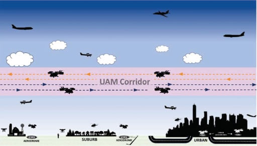
Shown here is an example of a proposed UAM corridor with “tracks.” UAM corridors would have specific rules, procedures and requirements, which would remain constant regardless of the class of the surrounding airspace. FAA graphic.
B is for “Byways” in the Sky
The airspace around vertiports will need developed to accommodate safe and quiet approaches and departures, along with the routing to and from each vertiport. This airspace will form the “byways” needed for UAM operations.
With the growing interest in the possibilities for UAM, key players in the industry, including NASA and the FAA, are working on a system for low altitude operations that will integrate into the current national airspace system (NAS). In July of last year, the FAA NextGen office released a “Concept of Operations” (ConOps) for UAM aircraft that focused on aircraft operating in “corridors” (see image below). In order for UAM to become a reality, it must be safe and scalable, which means individual states will need to overcome significant barriers to adoption and growth.
As depicted in the ConOps, the following principles and assumptions will be used when guiding the development of the UAM operating environment:
UAM vehicles will operate within a regulatory, operational, and technical environment that is incorporated within the NAS.
Any evolution of the regulatory environment will always maintain safety of the NAS.
Airspace management will be structured where necessary and flexible when possible.
Air traffic control (ATC) management will be conducted in compliance with a set of community developed and FAA-approved “community based rules” – more on that in the next section.
The FAA ConOps envisions the use of a “UAM Corridor” which is defined as “An airspace volume defining a three-dimensional route segment with performance requirements to operate within or cross where tactical ATC separation services are not provided.” The FAA expects to scale up UAM operations through the use of these corridors in which aircraft will operate without direct involvement from the current ATC system. Initially, the ConOps focuses on evolving current helicopter routes into UAM corridors (see image below)
However, according to Jay Merkle, the Executive Director of FAA’s Unmanned Aircraft Systems Integration, in comments he made at last month’s Vertical Flight Society’s eVTOL Symposium: “The corridor concept is not a scalable concept for high-volume, so we will have to figure out some way other than corridors. Corridors are great for aircraft that need to transit airspace infrequently, understanding that the traffic in that area typically gets priority. Those constructs just don’t work for … high-density UAM.”
The ConOps document provides an initial roadmap for how the U.S. might achieve high-volume urban air taxi operations while maintaining the safety of the NAS. Developed with input from NASA , industry and community stakeholders, the document outlines a “crawl-walk-run” approach. It assumes that initial UAM operations will use eVTOL aircraft that are certified to fly within the current regulatory and operational environment with an onboard pilot. Aircraft operating within the corridors will still have pilots onboard, but will also be equipped to exchange information with other users of the corridor in order to deconflict traffic without relying on ATC. Eventually, the FAA anticipates the system evolving to the point where UAM corridors form a complex, high-volume network through which UAM aircraft will fly autonomously (see image next page).
According to Merkel, airspace integration is a key issue facing UAM. “I think this is going to be a big challenge for this community. The traditional operators in this airspace will not easily yield their positions, and there will have to be some detailed discussions on how to do scale operations…”
Shown here are the different environments and types of operations in each environment. UAM Corridors are shown along with aerodromes supporting UAM operations. FAA graphic.
C is for Collaboration … and Communities
Interrelated to the “Aerodrome” and the “Byways” concepts is perhaps the most critical challenge to overcome in order to jump start UAM operations — “Collaboration.” Support for a broader urban planning capability relies on extensive collaboration with another “C” word — “Communities” – that build and live in the urban context. States will need to identify stakeholders to collaborate with, such as Public Private Partnerships, regulatory requirements, operations over people, modernizing infrastructure, etc. The key players in this dance should include OEMs, regulators, technology innovators, state & local leaders, and investors in the community who can discuss on-demand aviation for smart cities in order to create a new future for air transportation.
As mentioned in the previous section on “Byways,” the key players will need to agree upon “Community Business Rules” which are defined as a collaborative set of UAM operational business rules developed by the stakeholder community. These rules may be set by the UAM community to meet industry standards or FAA guidelines when specified, and they will require FAA approval.
Last year, Mark Moore, co-founder of Uber Elevate, spoke at the Vertical Flight Society’s 76th Annual Forum. “Right now, we’re working a great collaboration with the FAA, NASA and our OEM partners on coming up with an infrastructure requirements document.” Moore said Uber is aiming to start flying its partners’ first eVTOL aircraft between 2023 and 2024. That’s a great incentive to push for an infrastructure that does not yet exist. (see image 10).
At last year’s World Economic Forum in Davos, Switzerland, U.S. Secretary of Transportation Elaine Chao, gave a speech that encapsulated the sentiment of UAM collaboration and community. She said, in part: “To be fully deployed, UAM technology must first win the public’s trust and acceptance. UAM systems will be flying directly over and landing near neighborhoods and workplaces. So, it is imperative that the public’s legitimate concerns about safety, security, noise and privacy be addressed.” She challenged the industry “to step up and educate communities about the benefits of this new technology and win their trust.”
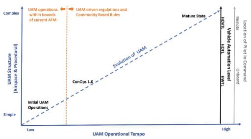
“UAM implementation is an evolutionary developmental approach starting with low-complexity, low-operational tempo operations and building toward an environment of higher operational tempo and the introduction of UAM airspace structure to mitigate an otherwise higher level of complexity. The concept will evolve…” says the FAA. FAA graphic.
S is for Services
The small “s” at the end of “ABCs” could stand for “services” — a topic that is too comprehensive and complex to be addressed here — it deserves its own article. While not quite as an urgent need as the three aforementioned “ABC” topics, a safe and prolific UAM operation will require flight tracking services, dispatching, and, eventually, the 800-pound elephant in the room known as Unmanned Traffic Management or UTM. The need for these services will grow exponentially once the UAM market proliferates. The FAA’s UAM ConOps addresses this with many pages and diagrams about the need for “providers of services for UAM.” These “PSUs” will be utilized by UAM operators to receive/exchange information via a network that enables safe, efficient operation within the UAM corridors without involvement by ATC.
Another critical service will be to provide weather information to UAM operators. This is already a challenge for helicopter operations, especially for Helicopter Air Ambulance community that conduct off-airport scene operations. Even with today’s array of 2,278 certified weather reporting systems in the Continental U.S. — a whopping 97.5% of this area does not have an FAA-approved weather source as per FAA’s Part 135.213 air taxi regulation because each of the reporting stations is valid only within a 5-mile radius.
What to Do NOW?
So, what should the industry do NOW and in the near term to accelerate infrastructure development so that the UAM pie in the sky has a place to roost? “We need to focus on getting POLICY to catch up to the technology” says Alexander. “We need to educate ourselves about what policy exists today and what needs to be developed. Hire someone who knows what policy is. Look and see what is going on in this space with ASTM and the FAA. Make comments during public comment periods. Anybody can comment.”
He also implores folks interested in UAM to get more involved. The eVTOL OEMs, FAA, trade associations, state authorities and other interested parties should actively participate at the numerous forums. “For example, I would highly encourage your readers to attend the Vertical Flight Society’s upcoming 4th Workshop on eVTOL Infrastructure to be held virtually from March 2–4.”
Good advice for those who want to grease the skids for UAM operations to arrive in a few years, rather than a couple of decades.


You must be logged in to post a comment.